The Laurel Mill area has a network of almost 10 miles of trails, a pavilion/warming hut, a vault toilet and parking area. GPS coordinates are 41.406923, -78.788698. From Ridgway head west on Main St. which will turn into Laurel Mill Rd. The parking area is on the right, about 4 miles from downtown Ridgway. There will be a sign 1/4 mile before the parking area.
The trails were built sometime around 1984 by a group of Ridgway residents who called themselves the 'Boot Jack Snow Gliders'. Led by Dave Love, a local visionary who also helped create the Clarion-Little Toby Rail Trail, volunteers linked abandoned logging roads with new trails to create 10.7 miles of trails on both sides of Laurel Mill Road (aka Spring Creek Rd or Route 3002). They purchased a Bachler two lane cross country ski grooming sled and groomed the trails. At first they used a snowmobile (not strong enough), then a Cushman Trackster (strong enough to do one lane), and finally a Bombardier Bombi (just right). They groomed the trails into the mid 2000's, but after several years of poor snow conditions they stopped and the Bombi feel into disrepair.
Today the trails are in varying states with some in very good condition and others may have ruts and soft spots (though we have put down over 50 tons of gravel to stabilize the worst areas). All trails are open for hiking, cross country skiing and snowshoeing. Bicycles are allowed on the north side trails, but not on the south side trails as the Forest Service has classified the area on the south side of the road as for remote recreation meaning that only non mechanized recreation is permitted. E-BIKES ARE NOT ALLOWED ON ANY TRAILS.
The trails on the north or parking lot side of Laurel Mill total just over 5 miles. Doing the longest loop is a 4 3/4 mile trip.
The Elk Loop totals 1.1 miles and is fairly level. It is grassy and only has a few wet spots.
The Scout Loop totals 1.15 miles and has some hills. The hill to the south of the Lewis Run Bridge is steep and stairs have been added. It would be challenging to ski the stairs. In the future we hope to relocate that portion of the trail so that it is not as steep.
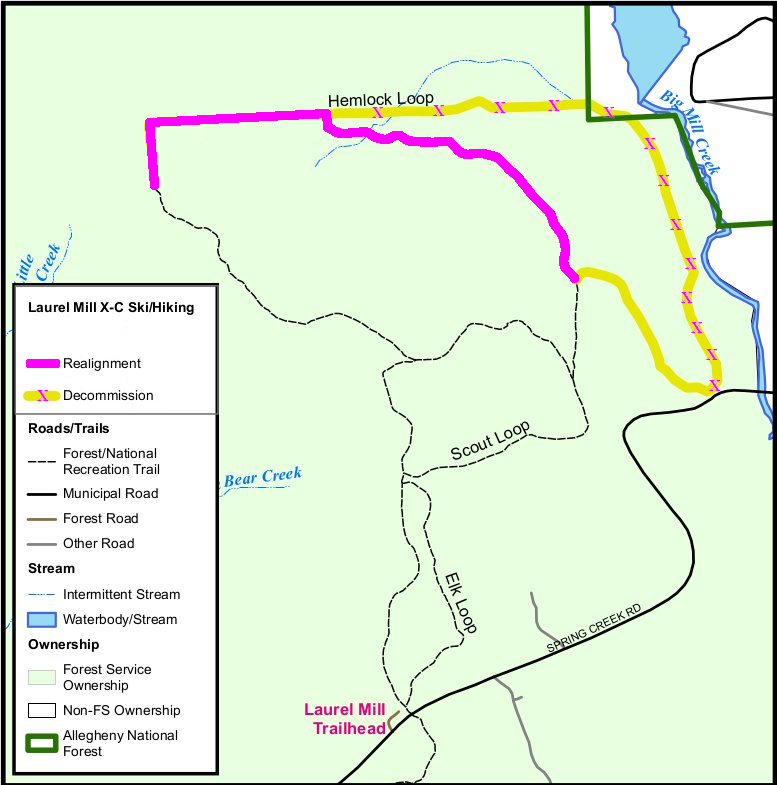
The Hemlock Loop totals 1.8 miles and has a few gentle slopes. While it was once 2.8 miles long, the Forest Service rerouted it in 2023 to eliminate a very steep segment and muddy areas that had water flowing in the trail. This new route is only roughed in and is very muddy right now. It is, however, a still beautiful hike. The Forest Service expects to finish the reroute at some point in the future. See the detail map on the right for more information about the reroute.
The trails on the south side of Laurel Mills total 5 1/2 miles and cover fairly level terrain. The few hills that exist are usually short so the trails are excellent for cross country skiing. Because these trails are on more level terrain, they are generally in better condition than the north side trails. Unlike the north side, this area is designated as a remote area and there are more restrictions on its use.BICYCLES ARE NOT ALLOWED ON THE SOUTH SIDE TRAILS.
The Laurel Mill Trail or Cook-Eli (which is the name on the sign) is a .4 mile connector from the parking area to the loops. It is fairly level with a gentle slope.
The Perseverance Loop totals 2 1/4 miles and covers gently rolling terrain. There is one significant hill and if you want to go down the hill, travel in a counter clockwise direction.
The One Mile Loop can add almost a mile to you trip and is fairly level. The "Sam's Slide" hill is a gentle downhill run if you're traveling clockwise on the loop.
The Sparrow Nest Loop is a 2 mile 'backwoods' loop which travels through the most remote area of Laurel Mill. The Gillis Flats area has a few springs in it and the trail is often wet in that area. These springs prevent snow from forming and this trail usually isn't skiable until there's been a good long cold spell to freeze the springs. There are several foot bridges on the trail which prevent us from running grooming equipment.
The Hemlock Loop has been rerouted. The new route has been roughed in, but as of September of 2025 it is still not complete. There are muddy spots and puddles. The 'old' Hemlock Loop has been closed, culverts removed and blocked off with felled trees. Most of the old north portion, spillway hill, and the part along Big Mill Creek are now impassable. There is a small section which runs down to Sandy Beach Park that is still open, though you have to bushwack to get to the road. Click on the map below to enlarge it.
While they were originally built as cross country skiing trails, the trails are great for hiking year 'round.
We regularly mow the main loops, but Hemlock and Sparrow Nest aren't mowed as often. The grass can get pretty tall, check for ticks when you finish your hike.
There can be wet spots and mud holes due to drainage issues. Expect to have wet shoes when you're done.
When walking or snowshoeing on groomed trails, please don't walk in the ski tracks as it messes things up for skiers.
Forest Service regulations prohibit bikes on the south side trails.
People often ask for suggestions on the 'easiest' trail. We suggest trying the trails on the south (not parking lot) side of the road as there aren't as many hills. Start on the Cook-Eli Trail (the maps say it is the Laurel Mill Trail, but the signs say Cook-Eli, we're still trying to figure that one out). It is a nice flat trail with a few small slopes. After a little under a half mile you will be at the intersection with the Perseverance Loop, take the left fork. You'll hit a few more small rises and after a little more than a mile you'll be at the intersection with the One Mile Loop. Think about how you're feeling as you've gone over 1 1/2 miles and it's 1 1/2 miles back to the parking lot if you turn around here.
If you feel like trying to glide down a hill (and walk up one later) turn right and continue on the Perseverance Loop. At the bottom of the hill you can either then turn left and follow the One Mile Loop signs for 3/4 of a mile and wind up back at the Perseverance/One Mile Loop intersection OR turn right which will take you back to the Perseverance Loop split (the shortest route to the parking lot). Either way, you will walk up a hill.
If you're not ready to try a hill, then go straight onto the One Mile Loop and then try some of the Sparrow Nest Loop, but turn back when you start to see hills.